by Catherine Schmitt
April 28, 2025
Knowing how much snow is on the ground, and how much water might flow downstream during the spring melt, is important information for everyone who lives in or visits Maine, especially those who reside next to rivers, operate hydroelectric dams, use water for manufacturing, manage drinking water supplies, and forecast river flooding.
Some hydroelectric dam operators have been measuring snow since the early 1900s. In 1993, the State of Maine and the U.S. Geological Survey began coordinating the various snow measurements being taken across the state, maintaining and analyzing data and sharing information with other agencies and communities. Jessie Meeks of Maine Geological Survey is the current lead coordinator.
How many people are involved in the survey?
“It’s kind of an all-hands-on-deck situation,” said Meeks. Meeks and one additional staff member sample many of the sites, usually 10-11 in a day. “They are long days,” she said. “We sample on a mix of public and private properties, but nearly everyone I encounter is interested and supportive of the effort, especially when they know the information is used to forecast flooding.”
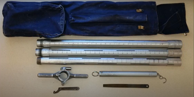
Snow depth is measured with an official “federal snow sampler,” a standardized metal tube pushed down into the snow. A window on the side allows the sampler to see the level of the snowpack and read the depth in inches from ruler markings. The snow tube is then suspended from a handheld scale, with weight later converted to calculate inches of water content.


Additional sites are monitored by 14 different partners, for a total of 134 sites. Not every site is sampled every time. And in 2024, there was so little snow, some sites, such as College of the Atlantic in Bar Harbor, didn’t sample at all.
- Allagash Wilderness Waterway
- Brookfield Renewable Energy Group
- Cobbossee Water District
- College of the Atlantic
- Great River Hydro, LLC
- Maine Environmental Science Academy – Fryeburg
- Maine Forest Service
- Maine Geological Survey
- National Weather Service Forecast Office, Caribou
- National Weather Service Forecast Office, Gray
- Nestle – Poland Spring Water Company
- SAPPI Limited
- U.S. Geological Survey, New England Water Science Center, Maine Office
- University of Maine – Earth and Climate Science
Snow depth and water content measurements are sent to Meeks monthly in January and February and weekly in March, April, and May, as long as there is snow on the ground.
How are the data used?
The data are analyzed by Meeks and staff from the Maine Geological Survey and U.S. Geological Survey and used to update statewide maps of snowpack water content.
Snow measurements also inform flood forecasts of the National Weather Service, which are used in the Maine River Flow Advisory Commission’s flood prediction report, and communicated to Maine Emergency Management Agency and county emergency management officials.
How would automated measurements support the snow survey?
Historically, snowpack measurements occurred in late winter and early spring, when the danger of flooding in Maine’s rivers and streams was greatest. But as winters have gotten warmer, snow cover is less consistent. More frequent thaws and rain-on-snow events affect the water content in snow and the volume and timing of runoff. There has been a shift toward earlier and more frequent measurements. This season, for the first time, surveying began in December.
With less predictability, there also is a need for more spatial coverage to create accurate forecasts, but adding new sites is costly. Recently, the Franklin County Emergency Management Agency contacted Meeks because they were concerned about flooding, and they agreed to take on measurements in the Rangeley area, filling an important gap in the western mountains.
According to Maine Emergency Management Agency, advances in remote sensing and satellite technology are allowing NOAA to provide overviews of snow cover and water content, but on-the-ground measurements still provide the most detailed estimate of local snowpack.
Automated sampling would capture important weather events that can rapidly shift the snow situation, said Meeks. “Automated measurements would allow more sites at high elevations in the mountains, the headwaters of the Saco, Androscoggin, Kennebec, and Penobscot rivers, which right now are difficult to access on a regular basis.”