Site Description
Property overview: Thompson Farm’s landscape, land-use history, and biodiversity are representative of a broad swath of New England’s coast and uplands. Part of the traditional lands of the Abenaki, Pennacook and Wabanaki People, the corridor of the Lamprey River must have been important both for provisioning and as a travel route. The land’s colonial history can be traced back to a 1701 deed to Valentine Hill issued by the town of Dover. Areas that are currently forested were largely cleared in the 18th and early 19th centuries and used for pasture, hay production, orchards, and cultivated agriculture. As across most of New England, agricultural intensity declined in the late 19th and early 20th centuries, and a majority of the land reverted to forest cover, though some remains in low-intensity agricultural use. Post-agricultural forests were generally dominated by white pine and shorter-lived, early-successional species. Forest succession and management have led to the current mix of forest species.
Current land cover comprises:
- 66% upland forest (a majority is actively managed for wood production and wildlife value)
- 16% forested wetlands
- 18% cleared land (agricultural fields, powerline right-of-way, roads and buildings)
Elevation ranges from 9-34 meters above mean sea level. LiDAR data are available from GRANIT.
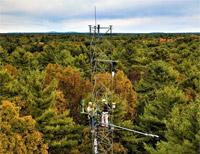
Climate: The climate is warm-summer humid continental (Köppen Dfb). Mean annual temperature and precipitation (1981–2010, from PRISM) average 8.5 ºC and 1150 mm, respectively. Precipitation is approximately evenly distributed throughout the year. NOAA has operated a Climate Reference Network station on the property (WBAN #54795; NH Durham 2 SSW) since 2010. A companion CRN site is located 7km NNE at Kingman Farm.
Soils are derived from glacial till, marine sediments, and glacial outwash (soil parent material map) overlying and partially derived from the Exeter Diorite bedrock. Drainage classes range from perennial wetlands to excessively drained sandy outwash (soil dranage map).
Hydrology: Woodman Brook is a perennial stream that drains Follet’s Marsh and bisects the property. Small perennial and seasonal wetlands are present across the property, some reflecting both past and current beaver activity.
Natural communities:
Major tree species include:
- eastern white pine (Pinus strobus)
- northern red oak (Quercus rubra)
- black oak (Quercus velutina)
- red maple (Acer rubrum)
- shagbark hickory (Carya ovata)
Other common tree species include:
- white oak (Quercus alba)
- eastern hemlock (Tsuga canadensis)
- American elm (Ulmus americana)
- American beech (Fagus grandifolia)
- sugar maple (Acer saccharum)
- black birch (Betula lenta)
- yellow birch (Betula alleghaniensis)
- black cherry (Prunus serotina)
Forest inventory plots are periodically visited by UNH Woodlands crews.
Common native shrub species include:
- witch hazel (Hammamelis virginiana)
- lowbush blueberry (Vaccinium angustifolium)
- beaked hazelnut (Corylus cornuta)
- maple-leaved viburnum (Viburnum acerifolium)
- winterberry (Ilex verticillata)
Invasive exotic plant species common across central New England’s secondary forests are present in various parts of the property, including:
- Asian bittersweet (Celastrus orbiculatus)
- autumn olive (Elaeagnus umbellata)
- glossy buckthorn (Frangula alnus); see also Bibaud (2019)
- burning bush (Euonymus alatus); see also Johnson (2013)
- common barberry (Berberis vulgaris)
- Japanese barberry (Berberis thunbergii)
- multiflora rose (Rosa multiflora)
- Morrow’s honeysuckle (Loniceri morowii)
- castor aralia (Kalopanax septemlobus); see also Lee et al. (2017)
The management of invasive plants has been an ongoing topic of research, and periodic invasive plant management efforts are underway.
Additional site descriptive data, including full plant species (>160) and bird species (>80) lists, can be found in the UNH Woodlands stewardship plan for Thompson Farm.