by Catherine Schmitt
November 18, 2024
Every week, from the first snowfall to the last, Scott McKim travels to the top of Whiteface Mountain by snowmobile – or, more often, skis – to check on the snow. He measures snow depth against a stake and with a coring tube, replaces batteries in cameras and sensors, and takes in the view before descending.
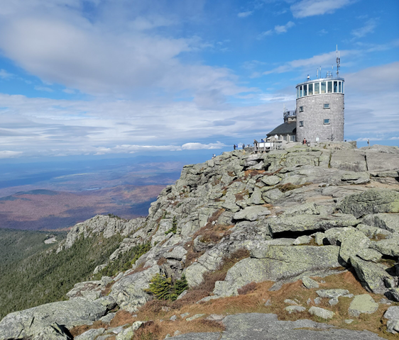
That view is often obscured by clouds. At 4,867 feet, Whiteface Mountain is the fifth-tallest mountain in New York, and the first mountain to intercept air masses as they move from west to east. In winter this means lots of ice and wind. Snow also accumulates, but is more often scoured and blown by the wind.
Weather monitoring began in 1937 at the summit, from a fire lookout station established in 1909. Whiteface Mountain soon took its place among other locations contributing to scientific knowledge of atmospheric chemistry and climate. Since the 1970s, equipment has been housed inside of a tower on the very top of the mountain, collecting data on air quality (including carbon monoxide, methane, ozone, particulates, and other pollutants like mercury and perfluoroalkyl substances or PFAS) in addition to temperature, precipitation, wind, air pressure, and snow. The Whiteface Mountain Observatory and Field Station is operated by the Atmospheric Sciences Research Center through University at Albany (State University of New York, SUNY).
“Measuring snow is crucial because it acts as both a natural reservoir and an early warning system for our changing climate. Snowpack data informs water management strategies, predicts potential droughts and floods, and supports everything from agriculture to hydroelectric power. By understanding snowfall and melt patterns, we can better safeguard our communities, sustain our ecosystems, and adapt to the shifting realities of climate change,” said McKim, Science Manager for the Whiteface Summit Observatory.

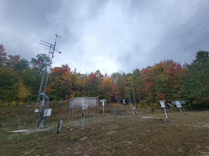
More snow accumulates at the base of the mountain, where the University of Albany Atmospheric Sciences Resources Center is housed in an old ski lodge. An adjacent field of instruments is a kind of museum of snow measurement equipment. There are snow scales, snow boards, snow stakes, precipitation funnels, buckets, filters, windvanes, and various sensors that contribute data to the National Weather Service, National Atmospheric Deposition Program, Environmental Protection Agency, and U.S. Geological Survey.
In 2016, Whiteface Mountain became part of the New York State Mesonet, one of 212 stations with a mission to “provide the best meteorological data, the best products, and the best services possible with the goal of saving lives and property while building a smart weather economy.”
When the Federal Emergency Management Agency provided funds for a statewide weather monitoring network after a series of damaging storms (Hurricane Irene, Tropical Storm Lee, Superstorm Sandy) highlighted vulnerabilities and data gaps across New York State, they likely had no idea that four years and more than $30 million later, six full-time technicians would be driving 100,000 miles a year to maintain hundreds of instruments that would be informing warnings and awareness of thunderstorms, tornadoes, fires, and blizzards. Such “mesoscale” events affect relatively local areas (150 miles or less) over short periods of time (minutes to hours), which is why so many stations are needed.
All of the sites measure precipitation and snow depth (every five minutes!), but 21 stations also measure snow water equivalent, or the amount of water within the snowpack. These sites are concentrated in the mountains, which are sensitive to hydrological changes from variability in snowfall, and are designed to complement similar monitoring across the Catskills. High elevation areas serve as headwaters: the Catskills protect the watersheds of New York City’s drinking water supply; snow falling on Whiteface Mountain eventually drains to the Hudson River, the St. Lawrence River, and Lake Champlain.
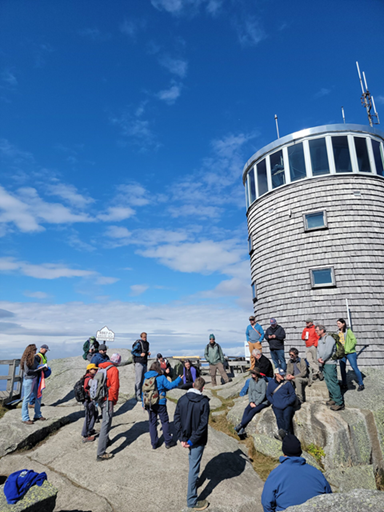
McKim, who is also the lead field technician for the New York State Mesonet, and software engineer Nathan Bain recently gave a tour of the Whiteface Mountain stations to the team from the Northeast Snow Survey Feasibility Study. They described how, in the six years since the network was completed, they’ve already figured out how to deal with blowing and drifting snow, compaction, icing, and melting. They’ve developed maps of frozen soil and methods for identifying freezing rain. They’ve also developed protocols and systems for site security and maintenance, as well as processing, storing, and providing data to various users.
One of the newer stations is in Lake Placid, in a rolling field that used to be a potato farm, surrounded by Adirondack foothills. Clouds hovered low in the sky, concealing Whiteface Mountain to the north. A massive solar panel and battery bank powers the station. A precipitation funnel, encircled by long flat pieces of steel that act as a windscreen, looks right at home enclosed in a steel hay bale feeder.
It was clear to everyone that the experience and expertise of the New York State Mesonet is going to be crucial to the success of a Northeast regional snow monitoring network.